Sunday, March 24, 2013

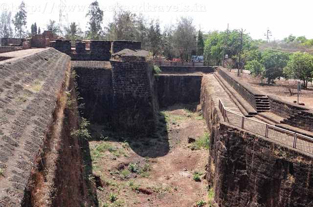
Mormugao Fort, Near Vasco, Goa


Mormugao Fort is near the internationally famous Marmagoa Harbor built to protect the harbor situated near the Vasco da Gama town. The scenic landscapes surrounding the Mormugao Fort have added to the tourism potential of the place. This fort covers in circumference, an area of six miles and contained very tall fortification, five prisons, a chapel and quarters for the sentinel. There were 53 guns and a garrison with 4 officers.
The fort also earned fame of being an important fortress on the western coast except the chapel and a segment of the boundary wall; little is left of this fort.
The Portuguese built the Mormugao Fort as a shield from incessant invasion from Maratha's  In 1624 construction got completed of the fort. This fort stands as a first-rate example of tough fortification. Though, much to see in the fort is not left apart from a Church and some strong walls. In olden days, the Mormugao Port used to be an imperative port. The fort has rich historical importance as there is priceless historical information hidden in the inscriptions of its wall.

Best time to Visit:
September to April

What to see?
Bastian, Fortification,

Water and Food
No water & food on the Fort.  Need to carry food and water along with.

Stay / Accommodation
No place to stay on the Fort. One can stay in Vasco city
          
Approximate Distance from Vasco Railway Station
4 Kms


For more photos see link below

Mormugao Fort, Near Vasco, Goa

Mormugao Fort, Near Vasco, Goa

Mormugao Fort, Near Vasco, Goa

Mormugao Fort, Near Vasco, Goa

Mormugao Fort, Near Vasco, Goa

For more photos see link below


Reaching Reis Mormugao Fort  from Vasco :-


View Larger Map

Sunday, March 17, 2013

Reis Magos Fort, Goa

The Fost is good condition and is renovated recently. Entry Fee is Rs. 50.
Reis Magos is a village located on the northern bank of the Mandovi River in Goa, gazing the capital city of Panjim. The village is famous for two of Goa’s very famous structures; the Reis Magos Fort and the Reis Magos Church - the first church of Bardez, Goa Predating Fort Aguada by half a century, a second, smaller fort that crowns the headland jutting into the narrowest stretch of the Mandovi, almost facing the capital city Panjim, is the Reis Magos Fort. This Fort, surrounded by sturdy laterite walls studded with typically Portuguese turrets, was erected in 1551 to protect the narrowest point at the mouth of the Mandovi estuary. It was enlarged subsequently on different occasions and finally re-erected in 1707. The fort formerly accommodated viceroys and other dignitaries newly arrived from, or en route to, Lisbon, and in the early eighteenth century proved a linchpin in the wars against the Hindu Marathas, who were never able to take it. The bastion was used as a prison. Though far inferior in size to the fortress of Mormugao, yet standing on an eminence, it commands a splendid view all around. It is in a good state of preservation and is defended by 33 guns and accommodation for a small garrison. Towards the east, at a little distance from it, flows a spring with abundance of excellent water, while at its base rises the church of the Reis Magos, ascended by a beautiful flight of stairs. This edifice was built on the ruins of a pagoda in 1550 by the Franciscans, with the sum allotted to them by the Government, and bears a crown on its façade, and the royal arms on its sanctuary and other places. The pavement is dotted with inscriptions, the most important of which, found in the sanctuary, indicated the spot enclosing the remains of Dom Luís de Ataíde, Count of Athoughia, who twice held the position of Viceroy of Portuguese India and Goa.
This Fort stands on the north bank of the Mandovi at Reis Magos, and is very much visible from the Panjim side of the Mandovi river. It was used as a residence for viceroys and later converted to a fortress. It was occupied briefly between 1798-1813 by the British Army. It was subsequently abandoned by the military and served as a prison until 1993. The Fort, originated as an armed outpost of the Adil Shah of Bijapur in 1493. When Bardez was conquered by the Portuguese in 1541, the Fort was built along with the church. From 1900, it lost its defensive role and was used as a jail and was finally abandoned in 1993 after which it was at the mercy of the elements, and had begun to crumble. Restoration work on the fort began in 2008 with the funds being provided by the UK-based Helen Hamlyn Trust, INTACH - a non-governmental organization dealing with restorations of monuments, and the Government of Goa. The fort is now converted into a cultural centre, besides being used a tourist attraction.


Best time to Visit:
September to April

What to see?
Bastian, Fortification, Cannons, Water cisterns,  Death Hole, Craft Centre

Water and Food
No water & food on the Fort.  Need to carry food and water along with.

Stay / Accommodation
There is place to stay on the Fort but need to take permission.

Places to visit around
Panjim, Aguada Fort, Calangute, Baga Beach, Chapora Fort

Approximate Distance from Panjim
7 Kms

For more photos see link below

Reis Magos Fort, Goa


Reis Magos Fort, Goa


Reis Magos Fort, Goa


Reis Magos Fort, Goa


Reis Magos Fort, Goa


Reis Magos Fort, Goa


Reis Magos Fort, Goa


Reis Magos Fort, Goa


Reaching Reis Magos Fort  from Panjim :-


View Larger Map

Sunday, March 10, 2013

Fort Aguada, Goa


Fort Aguada and its lighthouse is a well-preserved seventeenth-century Portuguese fort standing in Goa, India, on Sinquerim Beach, overlooking the Arabian Sea. The fort was constructed in 1612 to guard against the Dutch and the Marathas. It was a reference point for the vessels coming from Europe at that time. This old Portuguese fort stands on the beach south of Candolim, at the shore of the Mandovi River. It was initially tasked with defense of shipping and the nearby Bardez sub district. A freshwater spring within the fort provided water supply to the ships that used to stop by. This is how the fort got its name: Aguada, meaning Water. Crews of passing ships would often visit to replenish their fresh water stores. On the fort stands a four-store Portuguese lighthouse, erected in 1864 and the oldest of its kind in Asia. Built in 1612, it was once the grandstand of 79 cannons. It has the capacity of storing 2,376,000 gallons of water, one of the biggest freshwater storage's of the time in whole of Asia.
This fort is divided in two segments: the upper part acted as fort and watering station, while the lower part served as a safe berth for Portuguese ships. Whereas the upper part has a mote, underground water storage chamber, gunpowder room, light house and bastions, it also has a secret escape passage to use during time of war and emergency. The lighthouse at initial stage is used to emit light once in 7 minutes. In 1834 it was changed to emit light creating eclipse every 30 seconds, however it was abandoned in 1976. Fort Aguada was the most prized and crucial fort of Portuguese.
The fort is so large that it envelops the entire peninsula at the south western tip of Bardez. Built on the mouth of river Mandovi, it was strategically located and was the chief defense of Portuguese against the Dutch and Marathas. During the Salazar Administration, Fort Aguada was re-purposed for use as a prison primarily, some claim, for Salazar's political opponents.


Best time to Visit:
September  to April

What to see?
Bastian, Fortification, Cannon, Water cisterns, Light House

Water and Food
No water & food on the Fort.  But there are stalls outside fort.

Stay / Accommodation
No place to stay on the Fort. Once can stay in Calangute

Places to visit around
Reis Magos Fort, Calangute Beach, Baga Beach, Chapora Fort

Approximate Distance from Calangute
8 Kms 

For more photos see link below

Fort Aguada, Goa

Fort Aguada, Goa

Fort Aguada, Goa

Fort Aguada, Goa

Fort Aguada, Goa

Fort Aguada, Goa

For more photos see link below

https://www.facebook.com/media/set/?set=a.435649949886159.1073741917.359767254141096&type=1&l=96da27d31b


Reaching Fort Aguada from Calangute :-


View Larger Map

Sunday, March 3, 2013

Chapora Fort, Goa


The Chapora Fort occupies an important position which, in every direction commanded distant approaches. Rising above the wide Chapora River, long before the Portuguese arrived in Goa, was a fort in place of the present one built. Even after the Portuguese acquired Bardez, the fort changed hands several times and was much sought after. Trying to end the Portuguese rule in Goa, Prince Akbar joined his father’s enemies, the Marathas in 1683 and made this place his base camp and it became the northern outpost of the Old conquests. After the Portuguese recovered from a scary experience with the Marathas they learnt that they had to strengthen their northern defenses and provide shelter to the people there, but not until 1717 this present fort was built.
The brilliant site has steep slopes on all sides. The fort follows the outline of higher slopes, stands above the whole upland area having an irregular outer plan and uses the natural form to add defensive height to the fullest advantage instead of dry ditches being dug. At the top of the steep approach track, the main gate is small and unpretentious for such a large fort but narrow and deep. Depending on defense requirements, the positions of bastions each having the cylindrical turret that gives a special character are irregularly spaced with their enormous embrasures for cannon. The church that was dedicated to St. Anthony has disappeared and inside only a few signs of the barracks and housing that once filled this vast area are left. Now in a wide expanse of open space there is only a tumble of stones with a few herds of goats and cashew bushes. A natural valley to the beach protected by rocky promontories provides an excellent natural access to the sea.
Across the Chapora river, the Hindu ruler of Pernem, the Maharaja of Sawantwadi who was an old enemy of the Portuguese held the fort for 2 years after it fell to the Marathas in 1739 in its first test. When Goa's border moved northwards with the acquisition of Pernem as part of the New Conquests, the fort lost its military significance towards the end of the century. It is a pleasant place to wander that offers fantastic views north across the Chapora river to Pernem, south over Vagator and also far out to the Arabian Sea in the West.
This is the fort where shooting of famous Film Dil Chahta hai was done.


Best time to Visit:
September to April

What to see?
Bastian, Fortification, Water cisterns, Vagator Beach

Water and Food
No water & food on the Fort.

Stay / Accommodation
No place to stay on the Fort. Once can stay in Chapora.

Places to visit around
Anjuna Beach, Mapusa, Calangute Beach, Baga Beach, Aguada Fort, Reis Magos Fort

Approximate Distance from Calangute
9 Kms


For more photos see link below

https://www.facebook.com/Weekendtravels.in


                                                                                        Chapora Fort, Goa


Chapora Fort, Goa


Chapora Fort, Goa


Chapora Fort, Goa


Chapora Fort, Goa


Chapora Fort, Goa


Chapora Fort, Goa


Chapora Fort, Goa


 Reaching Chapora Fort  from Calangute :-


View Larger Map